Christopher Saxton’s Five Counties Map 1576
Saxton’s county maps were the first national cartographic survey of England. They, and later maps based on them, were very important for the preservation and distribution of the place name & literary phrase Beggars Bush. They may have contributed to the mistaken connection of beggars with the site at Godmanchester near Huntingdon.

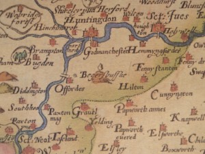
Extract from Saxton’s ‘Five Counties Map’(1576)
Saxton’s County Maps
Christopher Saxton published the first series of maps of English Counties. His maps showed county boundaries, towns, and rivers, with some woodland, parks and hills shown by schematic symbols, but not roads. They must have played a significant part in publicizing and extending the use of Beggars Bush as a place name, directly and through the numerous beautiful maps based on them – some of which are reproduced below.
The Godmanchester Beggars Bush
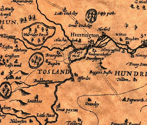
The Huntingdonshire Godmanchester Beggars Bush (Begersbussche) is a feature on Saxton’s “Five Counties” map of Northamptonshire, Bedfordshire, Cambridgeshire, Huntingdonshire & Rutland published in 1576.
The location is prominent as the first topographical symbol west of Cambridge towards the centre of the map, and the Midlands. It is also uniquely shown as a hill with a single tree on top.
We know that writers used maps from the error in Christopher Marlow’s Tamburlaine in which he refers to Zanzibar and the Ethiopian Sea as being on the western side of Africa. The error can be traced to a map by Abraham Ortelius in his world atlas Theatrum Orbis Terrarum (1570) a copy of which was available to Marlow at Corpus Christi College, Cambridge.
Given the popularity of Saxton’s it is reasonable to assume that anyone educated at Cambridge would have seen it, as would anyone with access to a good private library. Although Saxton did not originally include roads, they were later added, so it would also have come to the attention of people travelling north from either London or Oxford.
Saxtons’ maps were widely distributed. As well as being sold in atlas form the sheets were available for tuppence each. They formed the basis for all succeeding county maps for over one hundred years. The plates for them remained in circulation, passing through the hands of a variety of publishers, for more than two hundred years. As late as 1775 they were purchased by Cluer Dicey, a printer and publisher of chap-books which he circulated through a network of chapmen in towns markets and fairs around England. During this time the plates remained fundamentally the same, apart from the addition of some roads and boundaries. Therefore the Beggars Bush continued to appear on these re-prints even after the name ceased to be used locally.
Other Maps
In addition, Saxton’s maps were copied, with his landmarks being widely adopted. As a consequence this Beggars Bush appears on almost every important map of Huntingdonshire printed over the next two hundred years, and also some of Cambridgeshire. See the Huntingdonshire sheet of John Speed’s proof map Theatre of the Empire of Great Britaine (1611/12).
The coincidence of the continued publication of the name at this location well after the local use ceased, and the continued reference to the location in textbooks strongly suggests that they were sourced, perhaps indirectly from the maps, not from any local tradition or travellers information of actual activity.
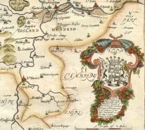
The Godmanchester Beggars Bush also appears on maps by Peiter van der Keere, (1599), William van Kip (1607), Jan Jansson (1646), John Ogilby’s “Britannia” (1675), Emanuel Bowen, in John Owen “Britannia Depicta” (1720), John Cowley (1744), and Hugh Burgh (1748).
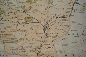
In 1785 Carington Bowles shows it was “Kings Bush vulg. Beggars Bush”, and thereafter it is shown as Kings Bush on new maps, although older versions continued to be sold. Many maps seem to have taken the symbol directly from Saxton as a symbol, rather than from any survey; Morden shows it detached from the road on the south.
As it appears on almost every important map of the area for the period 1576-1750 this must have been a significant mean by which knowledge of the name was spread.
Extract from A Mapp of Huntingdonshire
Richard Blome 1673
Robert Morden in Camden’s “Britannia” 1695
Note Beggars Bush is shown south of the road
also in Camden’s Britannia (1720) and in The New Description and State of England (1701)
Further Reading
Philip Saunders, Beggar’s Bush to King’s Bush, Records of Huntingdonshire, Vol.3 No.2, (1993) p.13-15
Neil Howlett, Beggar’s Bush Revisited, Records of Huntingdonshire, Vol.4 No.3 (2014) p.32-37
Beginner’s Guide: Re-engraving, by Ashley Baynton-Williams
Thanks
Posted: March 20th, 2011 | Filed under: Writers | Tags: Christopher Marlowe, Christopher Saxton, Godmanchester, Huntingdon, Huntingdonshire, bush, early sites, maps, proverb | No Comments »


Leave a Reply